Climate change is expected to reshape the global distribution of productivities. In theory, shifts in the spatial structure of economic conditions will affect international inequality by altering the pattern of international trade. In practice, it is hard to identify natural experiments to causally validate predictions about global conditions. This column describes research that exploits a global climatic phenomenon to estimate the general equilibrium consequences of changes in the spatial correlation of productivities.
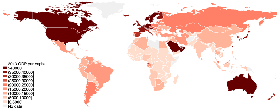
A glance at a map of countries’ incomes reveals a stark spatial pattern. Rich countries tend to neighbour other rich countries, while poor countries are often near other poor countries. This substantial spatial correlation of economic activity is evident in Figure 1, which depicts income per capita in the year 2013.
Figure 1 The spatial correlation of economic activity

Notes: GDP per capita in 2013. Source: Feenstra et al. (2015).
Economic output is spatially correlated in part because its determinants are. Neighbouring countries tend to have similar demographics, political institutions, and natural endowments. What are the consequences of spatial correlation? That is, what would happen to the global economy if countries’ productivities had the same global mean and variance but were reshuffled to be less spatially clustered?
The spatial scale of this question makes answering it an ambitious task. It concerns a counterfactual for the entire global economy. Clearly a randomised control trial is not possible. There is a growing literature exploring how natural experiments can be leveraged to answer general equilibrium, macroeconomic questions (Fuchs-Schuendeln and Hassan 2016, Nakamura and Steinsson 2018). Our question takes these considerations to an extreme by asking what happens when a global feature changes. To credibly answer this question, one needs a global natural experiment.
In a recent paper, we examine how the spatial correlation of productivity affects international inequality by exploiting a global climatic phenomenon that reshuffles the spatial structure of countries’ agricultural productivities (Dingel et al. 2019). We focus on how the spatial distribution of productivity affects welfare by altering the pattern of trade between countries.
Spatial correlation and the gains from trade
Spatial correlation increases inequality across countries by making the gains from trade more unequal. The intuition is straightforward. A country benefits when its trading partners are more productive, since they demand more of its exports and sell it cheaper imports. Because trade costs increase with geographic distance, a country’s gains from trade particularly depend on conditions in neighbouring countries. When spatial correlation is low, productivities are more evenly distributed across space, such that more and less productive countries experience similar neighbouring conditions, on average. When spatial correlation is high, a more productive country tends to have high-productivity neighbours and therefore enjoy larger gains from trade. Likewise, a less productive country tends to have low-productivity neighbours and therefore smaller gains from trade. As a consequence, when spatial correlation is greater, countries with higher productivity also enjoy higher gains from trade, raising international inequality.
A global natural experiment
Our main challenge is to find an exogenous driver of the global spatial correlation of productivity so that we can causally validate this prediction in the real world. We leverage insights about the geophysical features of a naturally-occurring global climatic phenomenon, the El Nino-Southern Oscillation (ENSO). Roughly every four to seven years, a stochastic natural process that originates in the waters of the tropical Pacific Ocean releases large amounts of heat into the atmosphere. This heat rapidly propagates eastwards within a relative short period of time. As a result, tropical economies near the equator all simultaneously experience hotter conditions, while the rest of the planet faces milder temperatures. The spatial evolution of ENSO-driven local temperatures is shown in Figure 2 for a 24-month period cantered around a typical ENSO event. Areas in red become hotter due to ENSO, while those in blue become cooler.
Figure 2. ENSO and the spatial evolution of local temperature

Notes: Each panel shows pixel-level correlation between the ENSO index in December and pixel-level monthly temperatures for 12 months before and 12 months after December. Red depicts positive correlation; blue depicts negative correlation.
We show that ENSO events over the last half-century affected not only temperature patterns but also drove the global spatial correlation of cereal yields, a standard measure of agricultural productivity. Consistent with our thought experiment, ENSO affects neither the annual global mean or variance of cereal yields.
With our global natural experiment in hand, we turn to data to estimate how the annual correlation between a country’s cereal yield and its gains from trade varies as ENSO alters the annual global spatial correlation of cereal yields. To measure gains from trade, we use a country’s share of expenditures on domestically produced goods, which is a sufficient statistic for gains from trade in a broad class of trade models (Arkolakis et al. 2012). The data confirm our prediction. During 1961-2013, a one-standard-deviation increase in the spatial correlation of cereal productivities increased the dispersion of welfare attributable to cereal consumption by 2%.
Forecasting climate change’s general-equilibrium consequences
This general-equilibrium mechanism is relevant for discussions of many global phenomena.
To demonstrate how to incorporate the consequences of spatial correlation into economics research, we explore an application that is of increasing concern to global citizens and academic researchers alike, i.e. the economic impact of anthropogenic climate change.
In recent years, there has been an explosion of research using effects from historical local temperature fluctuations to inform future climate impacts (Carleton and Hsiang, 2016). The strength of this prevailing approach is that it credibly infers causal effects. The downside, as is often the case with reduced-form techniques, is that the resulting climate impact projections tend to omit general-equilibrium consequences. In this case, reduced-form projections of future climate-change impacts essentially independently warm each location while holding temperatures elsewhere fixed at historical values. It amounts to asking what would happen if warming were to occur only in the US, only in China, only in Brazil, etc., and then assumes that the global economic impact of climate change is the sum of these independent events. This approach misses the unavoidable fact that anthropogenic climate change is a global phenomenon that is expected to simultaneously alter productivities across the planet.
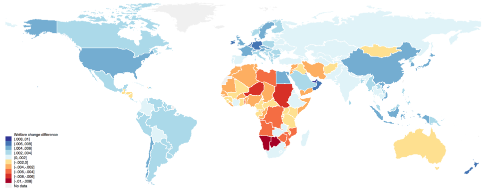
Our aim is to incorporate the general-equilibrium consequences of spatial correlation while preserving the advantages of a reduced-form framework. To do that, we incorporate the change in the spatial correlation of cereal productivity due to climate change into an otherwise-standard reduced-form projection. We find that adding this extra dimension to the exercise leads to a 20% greater projected increase in welfare inequality from cereal consumption by the end of the twenty-first century. Omitting the change in spatial correlation considerably understates the climate-driven welfare losses for most countries in Africa, as Figure 3 shows. This is because African economies are expected to jointly experience large productivity losses under climate change.
Figure 3 Differences in projected welfare changes due to spatial correlation under climate change (2013-2099)

Notes: Map shows the difference in projected country-level welfare change over 2013-2099 between reduced-form projections that include and omit changes in spatial correlation. Climate projections from CMIP5 ensemble mean under a business-as-usual (RCP 8.5) scenario.
While our climate impact projections are not literal forecasts of future climate impacts because they abstract from adaptation, migration, and other possible responses, they demonstrate how one can examine the general-equilibrium consequences of spatial correlation within a reduced-form framework. As such, this approach bridges the conceptual gap between estimates of causal effects and structural macroeconomic models of climate change impacts (Brock et al. 2014; Desmet and Rossi-Hansberg, 2015; Costinot et al. 2016; Krusell and Smith, 2016).
Since spatial correlation of economic features is pervasive, our prediction about spatial correlation may be relevant for empirical analyses of various other determinants of economic outcomes. For natural endowments in particular, spatial correlation may change following the relocation of existing endowments (e.g., migrating wildlife stocks), the discovery of new uses for them (e.g., solar and wind availability), or the discovery of new endowments (e.g., fossil fuel deposits).
Our research’s combination of general-equilibrium theory and a global natural experiment provides a framework for causal validation of general-equilibrium predictions. This work thus illustrates one way that causal-inference techniques, which have been much more widely adopted by applied microeconomic fields, can help answer macroeconomic questions.
References
Arkolakis, C, A Costinot, and A Rodriguez-Clare (2012), “New Trade Models, Same Old Gains?” American Economic Review 102(1): 94–130.
Brock, W, G Engstrom, and A Xepapadeas (2014), “Spatial climate-economic models in the design of optimal climate policies across locations.” European Economic Review 69: 78–103.
Carleton, T A and S M Hsiang (2016), “Social and Economic Impacts of Climate.” Science 353(6304).
Costinot, A, D Donaldson, and C Smith (2016), “Evolving Comparative Advantage and the Impact of Climate Change in Agricultural Markets: Evidence from 1.7 Million Fields around the World.” Journal of Political Economy 124(1): 205–248.
Desmet, K, and E Rossi-Hansberg (2015), “On the spatial economic impact of global warming.”Journal of Urban Economics 88: 16 – 37.
Dingel, J I, K C Meng, and S M Hsiang (2019), “Spatial Correlation, Trade, and Inequality: Evidence from the Global Climate.” NBER Working Paper, 25447.
Feenstra, R C, R Inklaar, and M P Timmer (2015), “The Next Generation of the Penn World Table.” American Economic Review 105(10): 3150–82.
Fuchs-Schundeln, N, and T A Hassan (2016), “Natural Experiments in Macroeconomics.” In Handbook of Macroeconomics. Vol. 2, 923–1012. Elsevier.
Krusell, P and A A Smith (2016), “Climate Change around the World.” mimeo.
Nakamura, E and J Steinsson (2018), “Identification in Macroeconomics.” Journal of Economic Perspectives 32(3): 59–86.
[To read the original paper, click here.]
Copyright © 2019 VoxEU. All rights reserved.
